Aeronautical experience requirements for the coveted instrument rating include a dual cross country flight. On February 28, 2022, the FAA Chief Counsel rescinded two earlier interpretations regarding the required content of that flight. But the rescission doesn’t end the story or the questions. As of this writing, there is an important question outstanding. We will discuss some thoughts about what we think is likely, but we need to await final word from the FAA.
Three Different Approaches
The requirements for the instrument rating for airplane, helicopter, and powered-lift in 14 CFR § 61.65 include a cross-country training flight. The length of the flight varies for the three ratings (250 NM for airplane and powered lift; 100 NM for helicopters), but each requires an instrument approach at each airport and “Three different kinds of approaches with the use of navigation systems.”
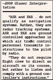
Seems straightforward. However, in March 2008, the FAA Chief Counsel responded to an inquiry from Danny Glaser. Mr. Glaser asked whether an Airport Surveillance Radar (ASR) or Precision Approach Radar (PAR) could be used. The answer was no. The Chief Counsel saw ASR and PAR as radar tracking systems used by controllers to give instructions to pilots, not as “navigation systems” used by aircraft crew.
Although this completely answered Mr. Glaser’s question, the interpretation went much further. The author of the Glaser letter added that the three approaches may not simply be “three different kinds of approaches” (the regulatory language) which use some type of navigation systems. Instead, said the Chief Counsel, the approaches “must use three different kinds of navigation systems” (emphasis in the interpretation). The applicant, the Glaser letter went on to say, must choose three different approaches from a short list:
- Non-directional beacon (NDB)
- Localizer-type directional aid (LDA)
- Very high frequency omni-range station (VOR)
- Global Positioning System (GPS)
- Simplified Direction Facility (SDF)
- Instrument landing system localizer (LOC)
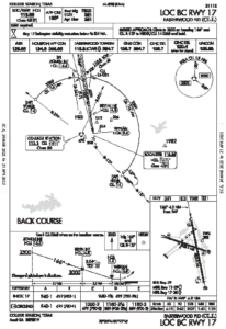
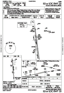
Intended or not, Glaser led to a very restrictive reading of the cross-country requirement.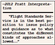 Many saw it as requiring three different instrument approaches, each of them using a completely different navigation system. An “instrument landing system localizer” is a single “kind of navigation system.” So, flying the full DME arc to track the localizer back course on the final approach course with step-down altitudes to the 600-foot AGL MDA on the LOC BC RWY 17 at College Station, Texas, is arguably the same as receiving vectors to intercept the final approach course and glideslope for the precision ILS RWY 35 at Sugar Land to its 200 and ¾ decision height because they are both localizer-based. Since they do not use different kinds of navigation systems, they cannot be used as two of the three approaches to satisfy the cross-country requirement.
Flight Standards apparently had its own questions about this and requested a clarification. In 2012, the Chief Counsel issued the Pratt letter in an attempt to clarify Glaser. The Pratt letter did nothing to help the situation. It said that the list of specific systems mentioned in Glaser, NDB, LDA, VOR, GPS, SDF, and LOC, “was not intended to exclude navigation systems that might be approved in the future.” What those might be, we still don’t know.
Most importantly, it did not address the problem Glaser created. The closest it came was passing the ball to Flight Standards, saying that branch “is in the best position to issue policy and guidance as to what constitutes the different kinds of approaches allowed.” But Pratt did not disown the controlling interpretation that there must be three different kinds of navigation systems used, restricting what Flight Standards might do. It’s no surprise Flight Standards didn’t run with the ball they were tossed.
Future Navigation Systems
I doubt the writer of Pratt intended to be ironic. When the NAS was filled with VORs, NDBs, SDFs, and other types of ground-based navaids, the restrictiveness of Glaser might not have been a big deal. As of March 2022, there remained almost 1500 VOR approaches but they are becoming less and less common. The number decreases almost every cycle due to a combination of VOR decommissioning through the Minimum Operational Network initiative, the separate program decommissioning “redundant” VOR and NDB approaches, and unrepaired failures.
In comparison, there are only 250 NDB approaches left (many on the chopping block). Even that number is illusory since most modern aircraft lack ADF capability; when someone upgrades their panels, it is often the first thing to go. The others? Well there are 31 LDA approaches, and a single SDF approach, the KMOR SDF RWY 5 in Morriston, Tennessee.
Sadly, with the diminishing number of options, the problem has not been merely academic. The reactions to Glaser restrictiveness have ranged widely. Some see Glaser as answering only the PAR/ASR question and ignore the “different kinds of navigation systems” language as an offhand remark not to be taken seriously.
Others look at the obvious differences between flying ILS and LOC approaches and see the glideslope as a “navigation system” distinction not mentioned in the interpretation. But at the opposite extreme, pilot examiners have been known to reject applicants who did an ILS at one airport and a LOC at another, pointing to the most restrictive interpretation.
Then There’s Carty
 As previously mentioned, the 2012 Pratt memorandum passed the ball to Flight Standards to set policy on the acceptability of approaches to meet the requirement. Early in 2021, as the result of a member inquiry, AOPA asked Flight Standards what if anything had been done since then. In May 2021, Flight Standards once again asked the Chief Counsel’s office for reconsideration of Glaser and Pratt. Flight Standards said it “is concerned that the interpretations create requirements that go beyond the language” of the regulation.
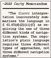
This time, in a February 28, 2022 memorandum to Robert C. Carty, the Acting Executive Director of Flight Standards, the Chief Counsel’s office rescinded both Glaser and Pratt. The memorandum includes a legal-style analysis that looks at regulatory definitions and the treatment of different tasks in the Instrument ACS, but the bottom line is that the 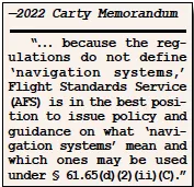 regulation requires “three different kinds of approaches,” not “three different kinds of navigation systems.” In a full reversal of Glaser and Pratt, the Carty memo also says that PAR and ASR are indeed “navigation systems” and nothing regulatory prevents their use to meet the IFR cross-country requirement.
The Rest of the Story
An important question remains. What approaches do qualify as three different types? Carty leaves the answer to Flight Standards. The full and complete abandonment of the Glaser and Pratt analysis leaves Flight Standards able to make policy to fit the realities of today’s environment and to adjust for tomorrow’s without the straight jacket of legal limitations.
As of this writing, Flight Standards has not acted officially. However, they have not been idle. Personnel at Flight Standards’ General Aviation & Commercial Division Training and Certification Group (AFS 810) have received and responded to several questions about which approaches count. A draft revision to Chapter 5 of the Flight Standards Information Management System (Order 8900.1 also known as FSIMS), has been written and is in the queue for approval.
Order 8900.1 guides aviation safety inspectors in performing their jobs. Chapter 5 deals with Airman Certification. While nothing is final until the proverbial (or virtual) ink is dry, informal responses to inquiries suggest Flight Standards is well aware of the rise of Performance Based Navigation and the reduced use of ground based navaids, and is prepared to take a reasonable and practical approach.
If I were to write my own ending, it would differentiate approaches based on the navigations sources used and whether the approach is flown with or without official vertical guidance. An ILS or LPV DA with a TERPS-vetted glidepath is official; “+V” advisory guidance to a VNAV or VOR MDA is not. So an ILS would be different from a localizer-only approach. PAR approaches (precision) would be treated as a different kind of approach from ASR (non-precision).
Perhaps vectors to the final approach course would be treated as different from a full approach using a course reversal or Terminal Arrival Area. In the best ending of all, RNAV approaches to LNAV, LP, and LPV minima would be different from each other, solving the potential problem of aircraft whose owners upgraded to GPS-only units like Garmin’s GPS 175 and GNX375 and choose to have no VOR or localizer receiver.
 Many saw it as requiring three different instrument approaches, each of them using a completely different navigation system. An “instrument landing system localizer” is a single “kind of navigation system.” So, flying the full DME arc to track the localizer back course on the final approach course with step-down altitudes to the 600-foot AGL MDA on the LOC BC RWY 17 at College Station, Texas, is arguably the same as receiving vectors to intercept the final approach course and glideslope for the precision ILS RWY 35 at Sugar Land to its 200 and ¾ decision height because they are both localizer-based. Since they do not use different kinds of navigation systems, they cannot be used as two of the three approaches to satisfy the cross-country requirement.

 As previously mentioned, the 2012
  regulation requires “three different kinds of